£250.00 – £289.00 ex VAT
Garmin GPSMAP 65 Series consists of two models of GPS. The GPSMAP 65 and the GPSMAP 65s. Both offer a rugged, all-terrain GPS navigation unit with a high-sensitivity receiver. Which uses multiband features to utilise multiple satellite networks for quick grid reference with accuracy. The unit is IPX7-rated waterproof. Features a colour screen that can be viewed in sunlight and has an impressive 16GB of memory for data storage. Such as updates, routes, map markers, geocaches, and more. This can be further upgraded with the addition of (at max) 32GB microSD card. The 65s model also provides users with a 3-axis tilt compass for accurate and easy navigation, a must-have in challenging environments. As well as a barometer providing you with current weather conditions and an altimeter which lets you know your current height above sea level. All of these within a comfortable to use, hand-held navigation unit.
Garmin GPSMAP 65 Series consists of two models of GPS. The GPSMAP 65 and the GPSMAP 65s. Both are ideal for challenging locations, such as those exploration geologists will find themselves in. Particularly during mineral exploration projects and surveys. A rugger, waterproof, button-operated GPS with a high-sensitivity receiver. The 65 series offers a host of features for outdoorsmen or those who undertake work outdoors.
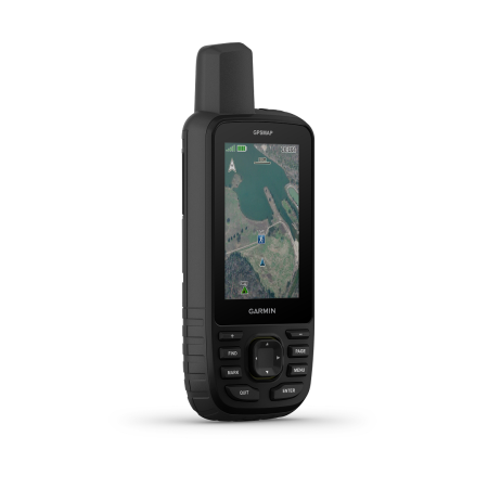
The 65 series of GPSs come out of the box featuring a 2.6-inch colour screen with transflective properties. Enable users to view the display even in the sun. Both models can run for up to 16 hours on only two AA batteries. Both contain up to 16 GB of memory as standard, but you can expand this with a microSD™ card (32 GB max version). This will allow further storage of data such as routes, waypoints, tracks, locations, map updates, and so on.
Thanks to its multiband features, the 65 series provides users with accurate navigation, quickly providing you with a grid reference within meters of your location. This is in part due to using a number of satellite networks: (GPS, GLONASS, Galileo, QZSS, and IRNSS). Furthermore, both the 65 and 65s models come with
Garmin GPSMAP 65 Series two models as the 65 and 65s. Both provide you with nearly the exact same specifications. Especially in terms of physical characteristics and operations. However, the 65s version also comes with an inbuilt altimeter and compass. These are in the form of ABC sensors, the altimeter provides you with accurate data in relation to your current height above sea level. A barometer provides relevant and accurate climatic conditions. Finally, a tilt-compensated 3-axis electronic compass ensures accurate directional navigation. Therefore, if you require that extra information that may be crucial to your trailing or survey. The 65s model is likely the option for you.
All of the above positives come within a rugged, waterproof outdoor casing. Made to take the brunt of whatever you throw at it when outdoors or in the field. For all of its features, it is fairly compact at only 6.1 x 16.0 x 3.6 cm and weighs 217 grams, including batteries. It features a 2.6-inch transflective, 65K colour TFT screen with 160 x 240 pixels. This provides you with a high-quality colour display that’s easy to read, whether it’s rain or shine. The casing is tough plastic and rubber, with an IPX7 water rating. Meaning it can withstand incidental exposure to water of up to 1 metre for up to 30 minutes. Therefore, it will easily operate following splashes or in the rain or snow.
Overalls, both the 65 and 65s models come as standard with plenty of features. This makes this model a go-to for a variety of users from a range of backgrounds. Their accuracy, protective casing, various abilities as well as adaptability and add-ons make for an excellent all-in-one navigation tool. Which sits comfortably within the palm of your hand. Many of their features, therefore, make the 65 series GPSs ideal for geologists undertaking mineral exploration surveys and mapping. Especially those in countries outside of Europe, where maps, locations, and other such important details and data are difficult to obtain or determine. These models allow for efficient and accurate grid references to be taken such as those of sampling sites, outcrop locations, potential drill rig set up, and so on. Such data is crucial for the project, and being without or inaccurate can prove costly.
